The LVM GEO team offers remote sensing services that include processing, analysis and service development of data obtained from various remote sensing instruments. Remote sensing data is an important informational resource and support for decision-making processes. The potential applications of these data are practically unlimited in scope. Remote sensing data can provide information on terrain, overgrowth, land use, objects and other geospatial information relevant to economic activities—data which would otherwise be impossible to obtain from field inspections alone.
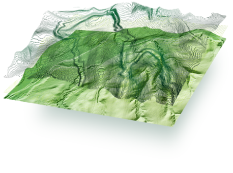
Processed remote sensing data can be used to create cartographic material, conduct spatial analysis or spatial modelling projects, or be used as a service in software applications. The LVM GEO team has created LIDAR digital elevation model, LIDAR tree crown sufrace model, LIDAR vegetation sufrace model to support JSC Latvia's State Forests business needs. These models provide significant information about forest stand age, forest stand height, forest density, relief, ravines, drainage ditches and other geospatial features. These remote sensing modules are already available to clients who use our products, but soon they will also be available to any user as open WMS service.
In remote sensing, one of the most informative data is the data obtained by Earth observation satellites. They provide more spectral information and additional detail in time, as they are extracted several times a day. These possibilities are also a challenge for data processing, analysis and management.
LVM GEO develops an Earth observation Data cube solution and offers time series analysis of satellite data and their derived products for change detection, creation of the latest available mosaics, and national or regional scale calculations. The currently created data layers are also available in the form of WMS services to any user. Read more about LVM GEO Data cube here.