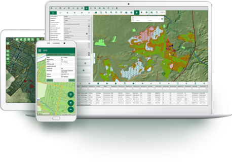
The LVM GEO Platform is among the largest and most versatile GIT products offered to customers in the market. The Platform provides users with numerous ways to view, process and analyse geospatial information. Its single unified database can be accessed via desktop, browser-based and mobile applications.

LVM offers customization and installation of the Platform, as well as access to continued product and service development, to clients requiring geographic information system support for their business activities. The modular structure of the platform allows for specific modules to be used as standalone systems or can be seamlessly integrated with other proprietary systems. The system and its interfaces are easily localised into any language.

Clients may choose a subscription to LVM’s infrastructure, including a full, secure system and infrastructure service package, or install the platform on their own IT infrastructure, providing for infrastructure maintenance with their own resources.

The LVM GEO platform consists of four modules: LVM GEO Web, LVM GEO Desktop, LVM GEO Mobile Sync and the platform’s data base – LVM GEO Database.

LVM GEO Web

LVM GEO Web is a web-based module that allows users to view, search and edit their company’s existing data layers or data tables from the LVM GEO database. Its main advantages include support for an unlimited number of users, user access administration, simple change management and a convenient user interface.

The map content section is the most important element of the module: within it, users can choose which data or background layers are visible, and consult a map window while working with charts and data tables without having to switch back and forth. The module also includes ability to create profile cards and bookmarks, customize table appearances, tag, measure and identify objects, and many others usability enhancements.

Maps can be printed or exported in a customised PDF file. Data layers are accessible by search, select or edit functions, and can be exported as a MS Excel file.

LVM GEO Mobile Sync

The LVM GEO Mobile Sync application is developed for tablets, desktops and laptops using the MS Windows operating system. With help of the application, users are able to measure and edit data layer geometries and enter information into the data tables.

The most significant advantage of the app is its ability to enable users to view, edit and collect data offline and in the field. Edited data can be transferred to the centralised LVM GEO Database using the data download and synchronisation functions. The module includes customizable forms, as well as data validation and autofill options. Layer access and data editing permissions in the mobile application are easily configured by LVM GEO developers.

LVM GEO Desktop

LVM GEO Desktop is a module based on ESRI's ArcGIS Desktop software, supplementing it with specifically designed tools. The solution is intended for professional geospatial data maintenance and complex spatial analysis.


LVM GEO Database

The foundational element of the LVM GEO platform architecture is the LVM GEO Database. The Database contains all spatial and tabular data used in the platform. This element of the LVM GEO platform also includes database maintenance tools, performance audits and automatic data calculations. The structure of the Database is fundamental to the adaptation of the platform to client needs, as the content and functional possibilities of the other modules are dependent upon it.

Development of the Database is specific and unique to each client company, and integration functionalities with other systems are usually developed at the database level.

Produktu header/footer attēls - platforma